Assessing Flood Risk for English Properties: What Homeowners Need to Know
By Housey · Last reviewed 9th of May 2026
Assessing Flood Risk for English Properties: What Homeowners Need to Know
Flood risk is an increasingly significant factor in buying, insuring, and improving a property in England. Climate projections point to more intense rainfall events and rising sea levels, while rapid urban development has placed pressure on drainage networks across much of the country. Whether you are considering a purchase near a river, living in a low-lying area, or planning works that could affect local drainage, understanding your property's flood risk status is a practical and financially important step.
Key points
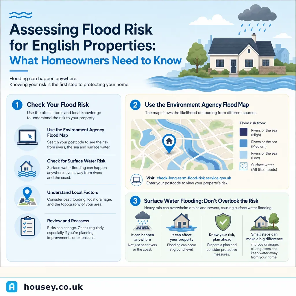
- The Environment Agency classifies land in England into Flood Zone 1 (annual flood probability below 0.1% from rivers and sea), Flood Zone 2 (0.1–1%), Flood Zone 3a (above 1%), and Zone 3b (functional floodplain that floods frequently or is designed to flood).
- Approximately 5.2 million properties in England are at risk of flooding from rivers or the sea, according to Environment Agency estimates.
- Surface water flooding — from rainfall overwhelming drainage systems — is the most common cause of property flood damage in England and affects properties in all flood zones, including Zone 1.
- A formal Flood Risk Assessment (FRA) is required for planning applications on sites in Flood Zone 2 or 3, and for sites larger than one hectare in Flood Zone 1.
- The Flood Re reinsurance scheme helps make buildings insurance more affordable for eligible properties built before 1 January 2009; properties built on or after that date are not eligible.
What the flood zones mean in practice
England's land is classified under the Environment Agency's flood zone system, which provides the starting point for planning decisions and insurance assessments. Boundaries are updated as the Agency revises its modelling — always verify the current position before making decisions.
Flood zone | Annual flood probability (rivers/sea) | Planning implications | Insurance implications |
|---|---|---|---|
Zone 1 (Low risk) | Less than 0.1% (1 in 1,000) | Standard development usually permitted; FRA not usually required | Standard insurance typically available |
Zone 2 (Medium risk) | 0.1–1% (1 in 1,000 to 1 in 100) | FRA required for planning applications | Some insurers apply higher premiums; Flood Re may apply |
Zone 3a (High risk) | Greater than 1% (1 in 100) from rivers | Sequential and exception tests apply; FRA required | Insurance harder to obtain; Flood Re eligibility important |
Zone 3b (Functional floodplain) | Floods frequently or is designed to flood | Most new residential development not permitted | Very limited insurance market |
Always verify the current flood zone using the Environment Agency's Flood Map for Planning (flood-map-for-planning.service.gov.uk) rather than relying on zone information from older searches or estate agent particulars.
Surface water flooding: the overlooked risk
River and coastal zones attract the most attention, but surface water flooding — caused when rainfall intensity exceeds the capacity of drains and sewers — is the most common cause of property flood damage in England. A home in Flood Zone 1 may still face meaningful surface water risk. Surface water risk is mapped separately via the Environment Agency's Long-Term Flood Risk Assessment tool and assessed by local lead flood authorities.
Red flags for surface water flood risk:
- The property sits at the bottom of a slope or in a natural hollow in the landscape
- Roads around the property regularly pool water after heavy rainfall
- Neighbours have reported previous internal flooding
- The property connects to an older brick-built combined sewer that may surcharge
- Significant housing or commercial development has occurred upstream in the catchment in recent years
- The seller has installed flood boards, raised door thresholds, or air brick covers
- Previous owners appear to have raised floor levels relative to neighbouring properties
How to check your property's flood risk
- Environment Agency Flood Map for Planning — shows river and coastal flood zones for any English address; free at flood-map-for-planning.service.gov.uk
- Long-Term Flood Risk Assessment tool — covers surface water, groundwater, and reservoir risk as well as rivers and sea; free at check-long-term-flood-risk.service.gov.uk
- Conveyancing environmental search — commissioned by your solicitor as standard; asks them to explain the flood risk section in plain terms
- RICS Home Survey — a RICS Level 2 or Level 3 survey will note visible signs of previous flooding and flag drainage concerns, though surveyors are not flood risk specialists and cannot produce a formal FRA
- Specialist flood risk assessment — a qualified flood risk consultant or drainage engineer can prepare a site-specific FRA for properties with known concerns
- Local authority strategic flood risk assessment (SFRA) — publicly available documents setting out local flood context, historic events, and planned infrastructure
Decision tree: what to do based on your flood zone
- Zone 1 (Low risk): Check surface water risk separately using the Long-Term Flood Risk tool. A standard conveyancing environmental search and RICS Home Survey are usually sufficient. Note any surface water red flags from the list above.
- Zone 2 (Medium risk): Request a formal FRA if planning any extension or significant works. Check insurance terms carefully before exchange of contracts. Consider a drainage survey to assess on-site drainage capacity and condition.
- Zone 3a (High risk): Take specialist advice before buying or beginning any development. A site-specific FRA is likely required. Check Flood Re eligibility before exchange. Commission a specific defect survey if internal flood damage is suspected.
- Zone 3b (Functional floodplain): Seek planning and legal advice before proceeding; most new residential development is not permitted in this zone.
- Any zone, surface water risk flagged by search or tool: Commission a drainage survey to assess the condition and capacity of on-site drains and connections.
- Any zone, visible signs of historic internal flooding: Commission a specific defect survey to assess cause, extent, and fabric implications.
What to ask before buying a property with flood risk
- What flood zone is the property in for both river/coastal flooding and surface water flooding?
- Has the property ever flooded internally? (Sellers are required to disclose this on the Property Information Form TA6.)
- Does any historic flood report or formal FRA exist for the property, and can it be provided?
- What are the drainage arrangements — are they adopted by the local sewerage undertaker or privately maintained?
- Is buildings insurance available for this property, and at what annual premium?
- Is the property eligible for the Flood Re reinsurance scheme?
- Are any flood resilience measures already in place, such as flood barriers, air brick covers, or non-return valves?
- Does the local authority's strategic flood risk assessment flag planned changes to local flood defences or drainage infrastructure?
Flood insurance and Flood Re
Flood Re is a joint scheme between the UK government and the insurance industry, designed to make buildings and contents insurance more affordable for homeowners in flood-risk areas. Key points:
- Available to UK homes built before 1 January 2009
- Not available to properties built on or after that date, most leasehold flats, housing association homes, or commercial properties
- Participating insurers cede high-flood-risk policies to Flood Re at capped premiums, making quotes more competitive for eligible homes
- Not all insurers participate — shop around or use a flood-specialist broker
- Flood Re does not guarantee affordable cover for every high-risk property; some remain difficult to insure
Check eligibility and find participating insurers at floodre.co.uk before exchanging contracts on a property in a flood-risk area.
When to get professional help
A conveyancing environmental search and general property survey are useful starting points, but they do not substitute for specialist assessment in higher-risk situations. Seek professional help if:
- The property is in Flood Zone 2, Zone 3a, or Zone 3b
- The environmental search or Long-Term Flood Risk tool flags surface water or groundwater risk
- There are visible signs of historic flooding — tide marks on walls, distorted flooring, newer plasterwork at low level, or recently replaced kitchen units in an older property
- The seller's Property Information Form (TA6) discloses any previous flooding
- You are planning an extension, new drainage, or development close to a watercourse
- You are struggling to obtain buildings insurance at a reasonable premium
How Housey can help
If flood risk is a concern at a property you own or are buying, Housey can connect you with qualified professionals. A RICS Home Survey provides a qualified surveyor's assessment of the property's visible condition, including any signs of previous water ingress. A drainage survey assesses the condition and capacity of on-site drainage. A specific defect survey can investigate a suspected previous flood event in detail. Request quotes from relevant professionals through Housey to compare costs and credentials.
Frequently asked questions
How do I check if a property is at flood risk in England?
Use the Environment Agency's two free online tools: the Flood Map for Planning shows river and coastal flood zones, while the Long-Term Flood Risk Assessment tool covers surface water, groundwater, and reservoir risk. Your conveyancing solicitor will also commission an environmental search as standard during the buying process, which flags flood risk. Review both sources before exchanging contracts.
Does flood risk affect property value?
Properties in high flood risk areas typically attract lower market values, higher insurance premiums, and can be more difficult to mortgage. The exact impact depends on flood zone, flooding history, resilience measures in place, and local buyer perception. Some mortgage lenders will not lend on properties in Flood Zone 3b without adequate flood insurance in place. A qualified valuer can advise on the specific impact for an individual property.
Can I get flood insurance on a high-risk property?
The Flood Re scheme makes buildings and contents insurance more affordable for eligible properties built before 1 January 2009. If your property qualifies, most participating insurers can offer cover. Properties built after that date, commercial premises, and most leasehold flats are not eligible for Flood Re and may face challenges in the standard market. Check Flood Re's eligibility tool at floodre.co.uk before purchasing in a flood-risk area.
What is a Flood Risk Assessment?
A Flood Risk Assessment (FRA) is a technical document prepared by a qualified flood risk consultant or drainage engineer. It evaluates a site's flood risk from all sources, assesses potential impact, and proposes mitigation measures. An FRA is required by national planning policy for development in Flood Zone 2 or 3, and for sites over one hectare in Flood Zone 1. Scope ranges from a desktop study to detailed hydraulic modelling depending on the site.
Does a RICS survey cover flood risk?
A RICS Level 2 or Level 3 Home Survey will note visible signs of past flooding — such as tide marks, distorted floors, or evidence of remedial work at low level — and flag drainage concerns. However, RICS surveyors are not flood risk specialists and cannot produce a formal Flood Risk Assessment or confirm flood zone status. If a surveyor flags concerns, a specialist assessment should be commissioned before exchange of contracts.
Sources and further reading
- Flood Map for Planning — Environment Agency
- Check your long-term flood risk — Environment Agency / GOV.UK
- Flood risk and coastal change: planning guidance — GOV.UK
- Flood Re: how it works for homeowners — Flood Re
- Prepare for flooding — GOV.UK
Useful next reads
 Surveys & Inspections
Insurance and Damage Reimbursement: Supporting Homeowners Through Property Recovery
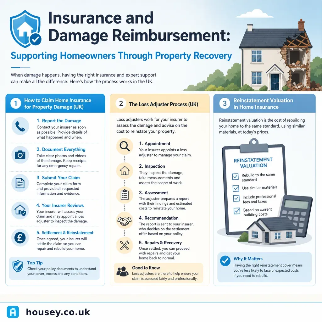
After property damage, your insurer will typically appoint a loss adjuster to assess the claim.
 Surveys & Inspections
CCTV Drain Survey Costs and What to Expect
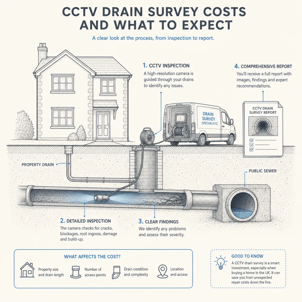
A CCTV drain survey in the UK typically costs between £150 and £400 for a standard residential survey covering one or two drainage runs.
 Surveys & Inspections
Identifying Unpleasant Odours in Your Home
Unpleasant smells in a UK home often point to damp, mould, a drainage fault, or — in the most urgent cases — a gas leak.
 Surveys & Inspections
Key Indicators of Good Property Structure and Condition
Good property structure is indicated by plumb walls, level floors, crack-free masonry at corners and above openings, an intact roof covering, and dry internal surfaces.
 Surveys & Inspections
Post-Survey Repairs and Negotiations
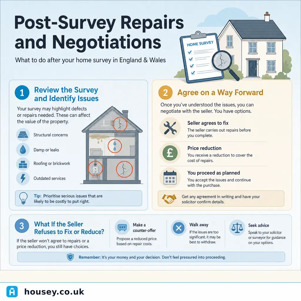
Sellers in England and Wales have no legal obligation to carry out repairs or reduce the asking price after a survey.