Drone Technology in Building Surveys and Roof Inspections
By Housey · Last reviewed 24th of May 2026

Drone Technology in Building Surveys and Roof Inspections
Roofs, chimneys, and high-level masonry are among the most expensive elements of a UK property to repair — and among the hardest to inspect safely without scaffolding or specialist access equipment. Drone surveys using unmanned aerial vehicles (UAVs) have become an established tool among UK surveyors and specialist inspection companies, offering high-resolution imagery of inaccessible areas at a fraction of the cost and programme time of traditional access operations. Whether you are buying a 1930s semi, managing maintenance on a Victorian terrace, or investigating a suspected flat-roof leak, understanding what a drone survey can and cannot tell you helps you decide where it adds genuine diagnostic value.
Key points
- Commercial drone operators in the UK must hold a valid CAA Flyer ID and, for most built-environment surveys near residential or commercial premises, an Operational Authorisation from the Civil Aviation Authority under the UK Drone and Model Aircraft Code.
- Drone surveys cannot substitute for a physical inspection when a RICS Level 2 or Level 3 Home Survey is required — RICS-registered surveyors must attend in person and must document any limitations where elements cannot be physically accessed.
- CAA rules restrict flight within congested areas (which includes most residential streets) without a specific Operational Authorisation; standard A2 Certificates of Competency do not automatically authorise operations over congested built-up areas.
- Optical cameras can detect surface cracking, missing or slipped slates, failed flashings, and blocked gutters, but cannot identify concealed structural defects beneath the roof covering without further physical investigation.
- Thermal imaging drone surveys can map moisture ingress, flat-roof delamination, and heat loss that is invisible to a standard camera, but require a meaningful temperature differential to produce reliable results and must be interpreted by a specialist.
What can a drone survey inspect?
Drone surveys are particularly effective at capturing:
- Roof coverings: Slipped, cracked, or missing tiles and slates; broken ridge and hip tiles; deteriorated mortar on lead-covered flat roofs.
- Chimneys and flues: Cracked stacks, failed or open pointing, deteriorated flaunching (the mortar securing chimney pots), and leaning or displaced masonry.
- Gutters and rainwater goods: Blockages, sagging sections, failed gutter joints, and missing downpipe connections.
- Flashings: Lead, felt, or EPDM flashings pulling away from abutment walls, failed upstands, and open joints at parapet walls.
- High-level masonry: Cracked or spalling brickwork above first-floor level, open perpend (vertical mortar) joints, and efflorescence indicating moisture movement.
- Flat roofs: Blistering, ponding, membrane splits, and vegetation colonisation.
What a drone survey cannot reliably detect includes concealed structural defects such as timber rot beneath tiles, sarking board failure, or rafter deterioration; the internal condition of a chimney flue; or the source and extent of damp at low level inside the property.
Drone surveys vs traditional access methods
Method | Best for | Not ideal for | Indicative cost | Key limitations |
|---|---|---|---|---|
Drone survey (optical) | Initial condition screening; large or inaccessible roofs; pre-purchase assessment | Concealed defects; RICS pre-exchange surveys; close physical investigation | £200–£500 | Surface only; weather-dependent |
Drone survey (thermal) | Flat-roof moisture mapping; heat loss assessment; energy retrofit planning | Precision diagnosis without follow-up; very cold or warm ambient conditions | £400–£900 | Requires temperature differential; specialist interpretation needed |
Scaffolding access | Full physical inspection; repair works; heritage or listed buildings | Routine pre-purchase screening on a standard property | £500–£2,000+ (scaffold hire alone) | Disruptive; slow to erect |
Rope access (IRATA-certified) | High-level urban facades; complex rooflines without suitable scaffold base | Properties without suitable anchor points | £600–£1,500+ | Specialist operatives required |
Ground-level binoculars or pole camera | Quick visual check to inform further action | Any meaningful defect diagnosis | £0–£150 | Very limited resolution and angle |
Indicative UK costs, last reviewed 2026-05-24. Costs vary by property size, location, and operator. Always obtain written quotes.
UK CAA regulations for commercial drone operations
Any drone survey carried out commercially in the UK is subject to Civil Aviation Authority regulations under the Air Navigation Order 2016 and subsequent amendments. The rules most relevant to building surveys include:
- Operational Authorisation: Flying in or near congested areas — which includes the vast majority of residential streets — requires an Operational Authorisation from the CAA beyond what a standard A2 Certificate of Competency permits.
- Proximity rules: Drones must generally remain at least 50 m horizontally from uninvolved people; operations closer than this require specific authorisation.
- Visual line of sight (VLOS): The operator must maintain direct visual contact with the drone at all times unless operating under a specific Beyond Visual Line of Sight (BVLOS) authorisation.
- Third-party liability insurance: Commercial operators should hold public liability insurance of at least £1 million; many carry significantly more. Always ask to see the current certificate before the survey date.
When commissioning a drone survey, confirm the operator holds the appropriate Operational Authorisation for your property's location — particularly in urban areas, near airports, or within restricted airspace near military establishments.
Which inspection method should you choose?
- Choose a drone survey if you want a cost-effective initial condition assessment of a roof or high-level facade, particularly on a large or steeply pitched roof where scaffolding would be disproportionately expensive relative to the information needed.
- Choose a RICS Home Survey if you are buying a property and need a comprehensive condition report — a surveyor attends in person and any drone imagery supplements, but does not replace, their investigation.
- Commission thermal imaging if you have a flat roof with suspected moisture ingress, or if you want to map heat loss before commissioning energy-efficiency improvement works.
- Use scaffolding access if a defect identified by drone requires close physical investigation, the roof is listed, or repair works are required imminently.
- Ask a chartered building surveyor if drone imagery has identified potential structural movement, significant water ingress, or any defect where cause and extent cannot be determined from aerial imagery alone. A structural survey may be appropriate.
What to ask your drone survey operator before instructing them
- Do you hold a CAA Operational Authorisation for congested or urban area operations? Can I see a copy?
- Are you insured for commercial drone operations, and what is the public liability limit?
- What camera resolution will be used, and in what format will images and video be delivered?
- Will I receive a written condition report or commentary alongside the imagery, or raw footage only?
- Do you offer thermal imaging, and is it included in the quoted fee or charged separately?
- How do adverse weather conditions affect the survey date, and what is your rescheduling policy?
- Can you identify and describe specific defects in the report, or will I need a follow-up physical inspection to interpret the findings?
When to get professional help
Drone imagery is a useful screening tool, but several situations require further professional assessment beyond what aerial imagery can provide:
- Any cracking visible in a chimney stack, particularly where it appears to be leaning, has open mortar joints, or shows stepped cracking through brickwork.
- Active water ingress inside the property that does not have an obvious or simple source identified from the drone imagery.
- A sagging ridgeline, uneven roof plane, or displaced verge tiles that may indicate movement in the roof structure.
- A flat roof with widespread ponding water or significant membrane failure, especially on a property you are considering purchasing.
- Any defect identified on a listed building's roof covering — consult a conservation specialist and your local planning authority before instructing repairs.
In all these cases, a roof survey or RICS Home Survey by a qualified chartered surveyor should follow the drone assessment.
How Housey can help
Housey connects you with qualified professionals for roof surveys, RICS Home Surveys, and structural surveys. If a drone inspection has flagged concerns, or you want a thorough pre-purchase assessment, use Housey to compare quotes from local surveyors who can advise on the appropriate level of investigation for your property type and its condition.
Frequently asked questions
Do I need planning permission to have a drone survey carried out at my property?
No. Having a drone survey flown over your own property does not require planning permission. The operator, however, must comply with Civil Aviation Authority regulations, which may require a specific Operational Authorisation depending on your location, proximity to other buildings, and local airspace restrictions — particularly near airports or in urban congested areas.
Will a drone survey reveal damp inside my roof?
A standard optical drone survey shows only the external surface. Thermal imaging drones can detect temperature anomalies that suggest moisture behind a membrane or heat loss through the roof structure, but these results require specialist interpretation and are not conclusive on their own. A physical inspection is needed to confirm any suspected internal damp.
How long does a drone roof survey take?
The flying element for a standard domestic property typically takes 30–60 minutes, depending on roof complexity and wind conditions. Report preparation adds further time; allow 2–5 working days from the survey date for a written condition report. Adverse weather can delay the flight, so factor in the possibility of rescheduling.
Are drone surveys suitable for listed buildings?
Drone surveys are non-invasive and can provide useful initial imagery of a listed building's roof without scaffolding. However, any repairs identified will require listed building consent and must use appropriate traditional materials. Consult your local planning authority's conservation officer before instructing any works following the survey findings.
Sources and further reading
- UK Drone and Model Aircraft Code — Civil Aviation Authority (CAA)
- Air Navigation Order 2016 — legislation.gov.uk
- RICS Home Surveys guidance — RICS
- Advice for owners of historic buildings — Historic England
- Working at height: a brief guide — Health and Safety Executive (HSE)
Useful next reads
 Surveys & Inspections
Drone Surveys: Applications and Benefits in Property Inspection
Drone surveys use unmanned aircraft to photograph and film roofs, chimneys, and hard-to-reach building elements without scaffolding.
 Surveys & Inspections
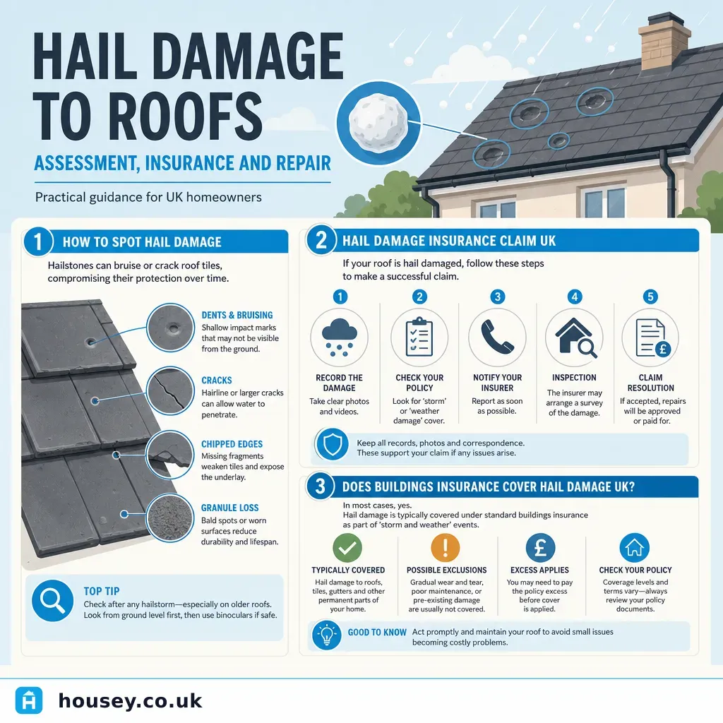
Hail Damage to Roofs: Assessment, Insurance and Repair
Hail damage to a roof commonly shows as cracked or chipped tiles, granule loss on flat roofs, dented flashings, and water ingress.
 Surveys & Inspections
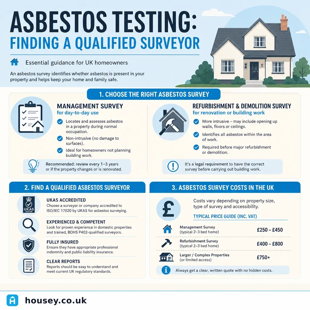
Asbestos Testing: Finding a Qualified Surveyor
Finding a qualified asbestos surveyor means choosing a company accredited by UKAS to ISO/IEC 17020, with analysts holding BOHS P402 or equivalent qualifications.
 Surveys & Inspections
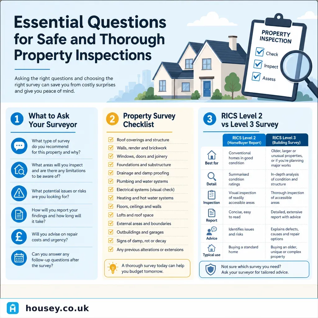
Essential Questions for Safe and Thorough Property Inspections
Before commissioning a property survey, confirm what type of inspection suits your property's age and condition, ask the surveyor what defects they will and will not assess, and understand what the report will recommend.
 Surveys & Inspections
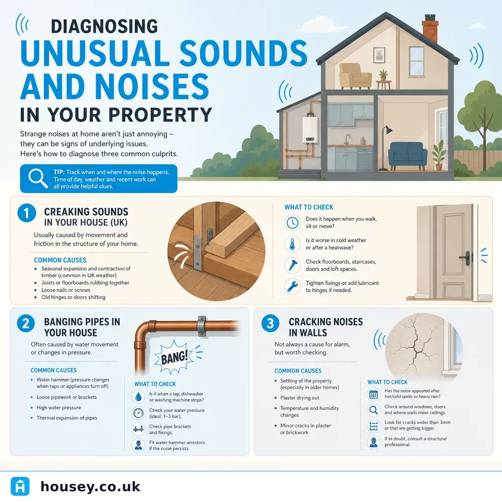
Diagnosing Unusual Sounds and Noises in Your Property
Most unusual sounds in a UK home have benign causes — thermal movement in roof timbers, water hammer in heating pipes, or normal settlement in new builds.