Landscaping a Waterfront Property: Challenges and Solutions
By Housey · Last reviewed 11th of May 2026
Landscaping a Waterfront Property: Challenges and Solutions
Owning a waterfront home — whether beside a river, lake, or tidal estuary — comes with a landscape unlike almost anything else in residential property. The interface between land and water creates a dynamic, often unstable environment where standard gardening instincts can cause more harm than good, and where regulatory requirements add layers of complexity that inland gardens simply don't face. From bank erosion and Environment Agency consents to species-rich planting and drainage design, getting waterfront landscaping right demands specialist knowledge from the outset.
Key points
- Works within 8 metres of a Main River, or 16 metres of a tidal main river, require a Flood Risk Activity Permit or registered exemption under the Environmental Permitting (England and Wales) Regulations 2016.
- Removing established vegetation from a riverbank or lakeshore can accelerate erosion dramatically, destabilising boundaries, drainage outfalls, and in some cases nearby structures.
- Sustainable Drainage Systems (SuDS) are a statutory requirement for most new drainage schemes in Wales under Schedule 3 of the Flood and Water Management Act 2010, and best practice throughout England.
- Native riparian plants — yellow flag iris, purple loosestrife, marsh marigold, and native sedge — outperform ornamental alternatives for bank stabilisation and ecological value.
- Properties in Flood Zones 2 or 3 (as defined by the Environment Agency flood map) may face additional planning constraints under the National Planning Policy Framework if a landscaping scheme includes any built elements.
Why waterfront landscaping is different from standard garden design
Standard garden design assumes a stable, well-drained plot where the main constraints are light, soil type, and boundary relationships. Waterfront sites introduce variables that can undermine even well-intentioned schemes.
Water level variation. Rivers and lakes fluctuate seasonally. Areas that look like dry ground in August may be submerged or waterlogged by February. Plants, hard surfaces, and drainage structures need to cope with this cycle without failing.
Erosion pressure. Moving water — even a slow-flowing river — exerts constant lateral pressure on banks. Remove the roots holding a bank together, introduce hard edges that reflect wave action, or disturb a natural swale, and erosion can escalate quickly. On tidal reaches, daily water movement compounds the problem further.
Ecological sensitivity. Watercourses and their margins are classified as priority habitats under the UK Biodiversity Action Plan. They support protected species — water voles (protected under the Wildlife and Countryside Act 1981), otters, and great crested newts — whose presence can halt or significantly alter planned works.
Regulatory complexity. Unlike most garden improvements, waterfront works routinely trigger Environment Agency permitting, Local Planning Authority notification, Internal Drainage Board consent, and — on navigable waterways — navigation authority permissions as well.
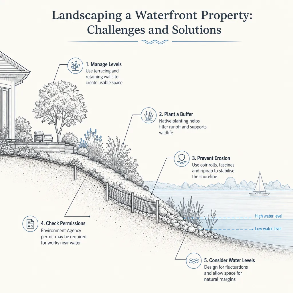
Managing erosion and bank stabilisation
Erosion is the most common and most costly problem on waterfront sites. Poorly planned clearance, hard-edging, or slope grading removes the root systems that bind soil, leaving exposed earth that is rapidly undercut by water.
Bioengineering approaches — sometimes called soft engineering — work with natural processes rather than against them. Techniques include:
- Live faggoting: bundles of living willow or alder stems staked into the bank at the waterline, which take root and create a self-renewing root mat.
- Coir rolls and geotextile matting: biodegradable erosion control materials that stabilise banks while new vegetation establishes.
- Slope re-grading: reducing bank angle to below 30 degrees dramatically reduces erosive force on the bank face.
- Marginal planting: establishing native sedge, rush, and flag iris at the water's edge creates a living buffer that dissipates wave energy.
Hard revetment — gabion baskets, sheet piling, concrete — is sometimes necessary on high-energy stretches, but it tends to displace erosion to adjacent unprotected areas and usually requires more extensive Environment Agency consent. A specialist riparian landscaper will typically consider bioengineering first.
Red flags that erosion is becoming critical
- Exposed roots along the bank edge with visible undercutting beneath
- Cracks running parallel to the waterline in lawn or terrace areas
- Leaning trees or fence posts along the bank top
- Turbid (cloudy, brown) water in a previously clear watercourse after rainfall
- Pipe ends or drainage outfalls being visibly undercut or exposed
If you notice any of these signs, seek professional advice before undertaking further work — the situation can deteriorate quickly once undercutting begins.
Drainage planning and flood risk
Waterfront properties often receive drainage from surrounding higher ground as well as experiencing inundation risk from the water body itself. A comprehensive drainage survey before starting any landscaping is strongly advisable.
Hard surfaces — patios, terraces, paths — increase runoff rates and must be managed through SuDS where possible: permeable paving, swales, rain gardens, or infiltration trenches. The Lead Local Flood Authority (usually the county or unitary council) can advise on local SuDS requirements and consenting thresholds for new drainage schemes.
Properties in Flood Zone 2 or 3 should obtain an up-to-date flood risk assessment before commissioning major landscaping works that alter ground levels, drainage patterns, or hard-surface coverage. The Environment Agency's online flood map is a useful starting point, but a professional assessment is required for formal planning submissions.
Choosing the right plants for a waterfront garden
Plant selection is arguably the most consequential design decision on a waterfront site. The wrong species — particularly invasive non-natives — can cause serious ecological and legal problems that are expensive to remedy.
Plant type | Best for | Bank stabilisation | Notes |
|---|---|---|---|
Native sedge (Carex spp.) | Marginal and wet zones | Excellent | Year-round root mat; high wildlife value |
Yellow flag iris (Iris pseudacorus) | Shallow margins | Good | Fast-spreading; keep in check |
Marsh marigold (Caltha palustris) | Wet margins, spring colour | Moderate | Excellent for pollinators |
Native willow (Salix spp.) | Bank face, coppiced | Excellent | Fast-growing; avoid planting near drains or foundations |
Purple loosestrife (Lythrum salicaria) | Open margins | Moderate | Attracts bees and butterflies |
Bamboo | Not recommended near water | Poor | Destabilises banks; invasive root system; very difficult to remove |
Japanese knotweed | Never plant — illegal to allow to spread | None | Schedule 9 invasive species under the Wildlife and Countryside Act 1981 |
Invasive non-native species such as Himalayan balsam, Japanese knotweed, and giant hogweed are frequently found on waterfront sites. Treating or removing them requires compliance with the Wildlife and Countryside Act 1981 and, in some cases, a waste carrier licence for excavated material. A specialist contractor should assess and manage these species — do not attempt removal without professional guidance.
Environment Agency consents and planning permissions
Works near water in England and Wales are regulated at several levels:
Environment Agency (England): Flood Risk Activity Permits are required for most works within the flood risk activity distance thresholds from Main Rivers. Lower-risk works may qualify as exempt activities but must still be registered with the EA. The EA's online self-service portal handles both permit applications and exemption registrations. Allow 2–4 months for a standard permit.
Internal Drainage Boards (IDBs): In low-lying drainage districts — common in East Anglia, the Somerset Levels, and similar flat areas — an IDB consent is required for works near ordinary watercourses, including small ditches and field drains. Check whether your property falls within an IDB district via the Association of Drainage Authorities.
Planning permission: Hard structures — retaining walls, jetties, boathouses, decking over water — will usually need planning permission. Permitted development rights are more restricted in flood zones, Areas of Outstanding Natural Beauty, and on designated sites such as SSSIs. Always check with your Local Planning Authority before starting.
Navigation authorities: On navigable rivers managed by the Canal and River Trust, the Environment Agency navigation function, or an independent authority, works affecting the waterway channel may require separate consent in addition to EA permitting.
Pre-project consent checklist
When to get professional help
Most waterfront landscaping projects benefit from specialist input at the outset rather than retrospectively. Seek professional advice if:
- You are proposing any works within the Environment Agency flood risk activity thresholds
- There are signs of active bank erosion or recent slippage
- Protected species — water voles, otters, great crested newts — may be present on or near the site
- The site falls within a SSSI, AONB, Green Belt, or conservation area
- You need to apply for a Flood Risk Activity Permit or Internal Drainage Board consent
- The project involves retaining structures, significant ground level changes, or drainage alterations
A qualified landscape architect or specialist riparian landscaper — ideally with direct experience of EA permitting — can advise on ecology, drainage, consents, and planting within a single project brief. Managing regulatory and ecological complexity without professional guidance risks enforcement action, costly remediation, or lasting harm to legally protected habitats.
How Housey can help
Housey connects you with specialist landscapers and garden designers experienced in complex and environmentally sensitive sites, as well as drainage contractors who can survey and design compliant drainage solutions for waterfront properties. Describe your project to receive quotes from vetted local professionals.
Frequently asked questions
Do I need Environment Agency permission to landscape my riverbank garden?
In most cases, yes — or at least an exemption registration. Works within 8 metres of a Main River (16 metres for tidal rivers) fall within the Flood Risk Activity zone and require either a permit or registered exemption under the Environmental Permitting (England and Wales) Regulations 2016. Contact the Environment Agency early; consenting can take two to four months.
Can I build a jetty or decking at the water's edge?
Structures projecting over or into water almost always need planning permission and Environment Agency consent, and possibly a navigation authority licence. Permitted development rights do not generally extend to structures at or over the waterline. Submit a pre-application enquiry to your Local Planning Authority before commissioning any drawings or quotes.
What plants should I avoid near a river or lake?
Avoid Japanese knotweed, Himalayan balsam, giant hogweed, and floating pennywort — all listed under Schedule 9 of the Wildlife and Countryside Act 1981. Bamboo is not legally restricted but destabilises banks and is very difficult to remove. Use native riparian species such as native sedge, yellow flag iris, and marsh marigold instead.
How do I find out if my property is in a flood zone?
The Environment Agency's flood map for planning on GOV.UK shows flood zone designations across England. Welsh properties use Natural Resources Wales flood mapping. These give an initial indication, but a formal flood risk assessment from a qualified engineer or hydrologist is needed for planning applications and formal risk management decisions.
Could waterfront landscaping affect my home insurance?
Landscaping that reduces bank stability or increases impermeable surface area could affect your flood risk profile. Inform your insurer before major works begin. Improving bank stabilisation through bioengineering measures — live faggoting, marginal planting — is unlikely to increase risk and may support a flood resilience argument when renewing cover.
Sources and further reading
- Flood risk activities: environmental permits — GOV.UK
- Wildlife and Countryside Act 1981 — legislation.gov.uk
- Check the long-term flood risk for an area in England — Environment Agency / GOV.UK
- Magic Map Application — Natural England / DEFRA
- Association of Drainage Authorities — ADA
- Invasive non-native species: guidance — GOV.UK
Useful next reads
 Improvement & Build
Pervious Concrete Surfaces: Modern Sustainable Driveway Solutions
Pervious concrete (also called porous or no-fines concrete) is a specialist concrete mix with large voids that allow rainwater to pass through the surface and into the sub-base below.
 Improvement & Build
Permeable Driveway Installation and Cost Guide
A permeable driveway lets rainwater drain through or around the surface rather than running off into the road or drainage system.
 Improvement & Build
Retaining Wall Installation: Cost, Design and Maintenance
A retaining wall holds back soil on a sloped or banked site.
 Improvement & Build
Improving Your Driveway: Options, Costs and Considerations
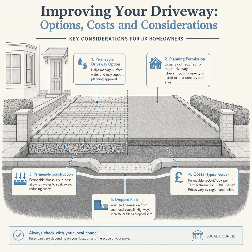
Installing a new driveway with a non-permeable surface larger than 5m² over a front garden in England requires planning permission unless water drains to a permeable area.
 Improvement & Build
Drainage solutions for window wells and basement windows
Most UK window wells manage water through a gravel-filled sump at least 200 mm deep or a plastic liner fitted with a drain outlet connected to a soakaway or drainage system.