Land Survey Costs: Understanding Property Boundaries
By Housey · Last reviewed 30th of May 2026
Land Survey Costs: Understanding Property Boundaries
Questions about land survey costs typically arise at several distinct points in a property owner's journey: before a planning application, when a boundary disagreement develops with a neighbour, ahead of a purchase where the plot extent is unclear, or when an architect needs accurate dimensions before drawing up an extension scheme. Knowing which type of survey you need — and what a fair fee looks like — prevents both overpaying and instructing the wrong professional for the task.
Key points
- HM Land Registry title plans are drawn at 1:1,250 scale in urban areas and 1:2,500 in rural areas, and are not intended to show the precise legal boundary — Land Registry Practice Guide 40 states explicitly that the filed plan indicates general position only.
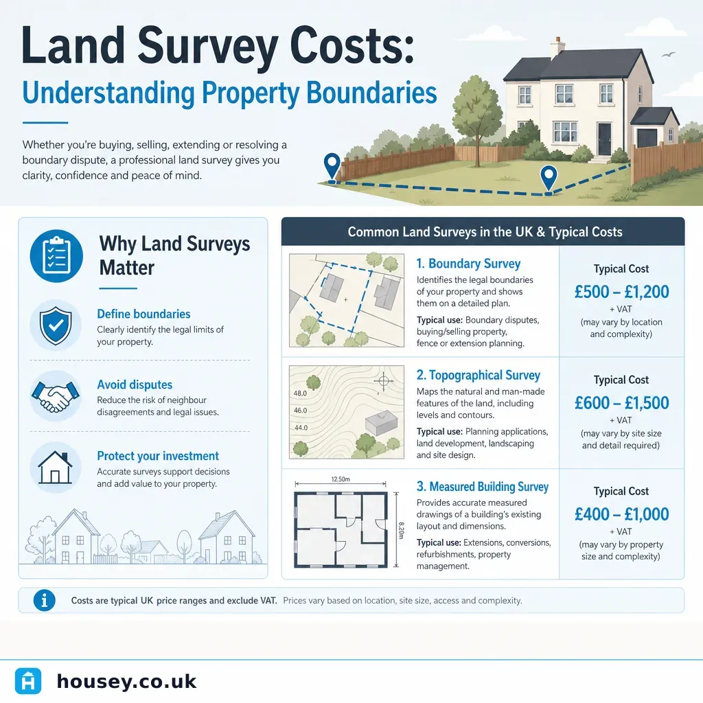
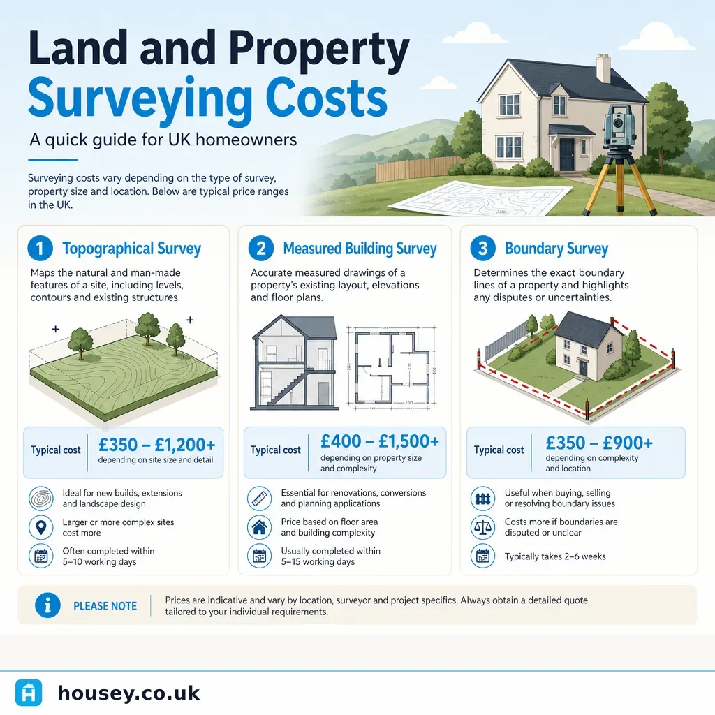
- A boundary survey by a chartered land surveyor typically costs £500–£2,000 for a standard residential property; complex or disputed boundaries with extensive archive research may cost considerably more.
- Topographical surveys — required for most planning applications and new-build or extension designs — typically cost £600–£2,500 for a standard residential site, rising for larger plots or steeply sloping ground.
- Measured building surveys, used by architects as a base for extension and conversion drawings, typically cost £800–£3,000 for a standard UK house depending on floor area and the level of CAD or BIM detail required.
- Under section 60 of the Land Registration Act 2002, a homeowner can apply for a determined boundary — a formally recorded legal boundary position — but this requires a qualified boundary surveyor's plan and statutory declaration and a Land Registry application fee of £90.
Which type of land survey do you need?
The term land survey covers several distinct professional services. Using the wrong type wastes money and can delay a planning application or legal process.
Survey type | What it produces | When you need it | Typical professional |
|---|---|---|---|
Boundary survey | Expert report defining the legal boundary position relative to physical features and title evidence | Boundary dispute; clarifying plot extent before purchase; determined boundary application | RICS-accredited land or boundary surveyor |
Topographical survey | Detailed plan showing land levels, features, trees, boundaries, drainage, and services | Planning application; new-build or extension design; drainage or landscaping design | RICS land surveyor or specialist topographical survey firm |
Measured building survey | Floor plans, elevations, and sections of an existing building to precise dimensions | Architect brief for extension or conversion; planning drawings; permitted development evidence | RICS land or building surveyor; architectural surveyor |
Rights of way or easement survey | Map of access rights, drainage rights, or easements affecting the land | Purchase due diligence; development appraisal; rights dispute | Solicitor-instructed surveyor or specialist |
Drainage and utility survey | Location and depth of underground services | Any ground-breaking work; new foundations; extensions near existing drains | Specialist drainage or utility surveyor |
Decision guide: which survey do you need?
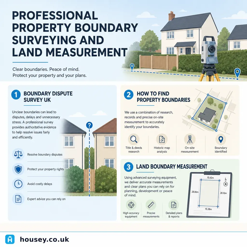
- Choose a boundary survey if you are in a dispute with a neighbour about where your boundary lies, if you are buying a property where the plot extent does not match the physical features, or if you want to apply for a determined boundary at HM Land Registry.
- Choose a topographical survey if you are about to submit a planning application, appoint an architect for a new build or extension, or design drainage or landscaping that depends on accurate ground levels.
- Choose a measured building survey if you are appointing an architect for an extension or conversion project and they need accurate existing drawings as a working base.
- Ask a solicitor first if you have a legal boundary dispute — the surveyor's instruction may need to come from your solicitor to ensure the evidence is admissible and the expert is properly appointed.
- Check with your local planning authority if the survey is being prepared for a planning application — some local planning authorities specify the accuracy standard and scale they require for submitted topographical surveys.
How much does a land survey cost in the UK?
Indicative UK costs, last reviewed 2026-05-30. Costs vary by region, site complexity, access, and output requirements. Always obtain at least three itemised quotes.
Survey type | Indicative cost range | Key cost drivers |
|---|---|---|
Boundary survey (residential) | £500–£2,000 | Boundary length; title deed complexity; archive and historic OS map research |
Topographical survey (residential plot) | £600–£2,500 | Site area; level change across the plot; number of features; inclusion of tree survey |
Measured building survey (standard house) | £800–£3,000 | Floor area; number of storeys; CAD output layer standard; BIM level of detail |
Determined boundary application (Land Registry) | £90 (Land Registry fee) + surveyor fees | Surveyor preparation time; complexity of legal boundary evidence |
Rights of way or easement survey | £500–£2,500+ | Research depth; title complexity; number of affected registers |
What affects the cost of a land survey?
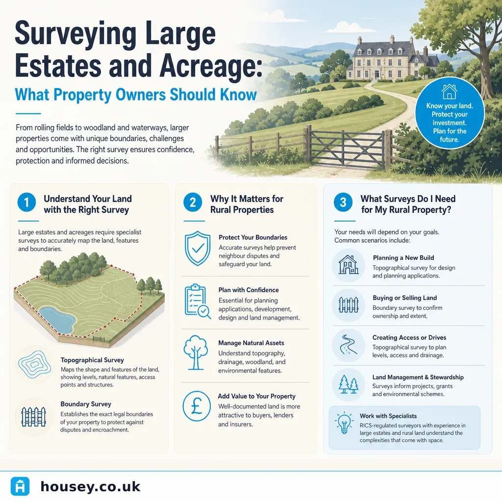
Site complexity: A flat, rectangular urban plot with a clear fence line is straightforward to survey. A rural property with overgrown boundaries, historic hedgerow lines, ambiguous title registers, or multiple owners will require more research and fieldwork time, which increases the fee.
Archive and title research: Boundary surveys often require the surveyor to obtain and interpret historic Ordnance Survey maps, conveyancing documents, and Land Registry title history going back several decades. This desk research can add several hours to the overall cost.
Output format and accuracy standard: A topographical survey for planning submission often needs to be delivered as an AutoCAD DWG file to specific layer naming conventions and at a stated accuracy standard. BIM-level measured building surveys (LOD 300 or above) cost more than a basic floor-plan-only output.
Access and logistics: Properties that are tenanted, that require key collection from a managing agent, or that sit on a busy road requiring traffic management will add cost and programme time.
A common misunderstanding: what HM Land Registry title plans do and do not show
Among the most frequent misunderstandings in UK property boundary matters is the assumption that the title plan filed at HM Land Registry shows the exact legal boundary. It does not. Title plans are based on Ordnance Survey mapping and are drawn at 1:1,250 in urban areas — at this scale, one millimetre on the plan represents 1.25 metres on the ground. The plan indicates the general position of the registered land; it is explicitly not an engineering-quality survey document.
If you need certainty about where a boundary falls, or wish to have it formally recorded so it binds successors in title, you can apply for a determined boundary under section 60 of the Land Registration Act 2002. This requires a qualified boundary surveyor to prepare a precise T-mark plan and statutory declaration supported by evidence. Land Registry Practice Guide 76 explains the application process.
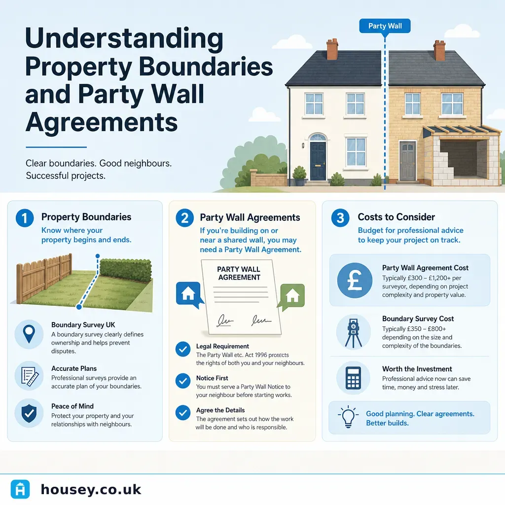
A separate but related point: the Party Wall etc. Act 1996 governs certain works near or on a shared boundary. A party wall surveyor — a distinct role from a land surveyor — must be appointed when notifiable building work is proposed. The two disciplines are often confused.
Quote comparison template
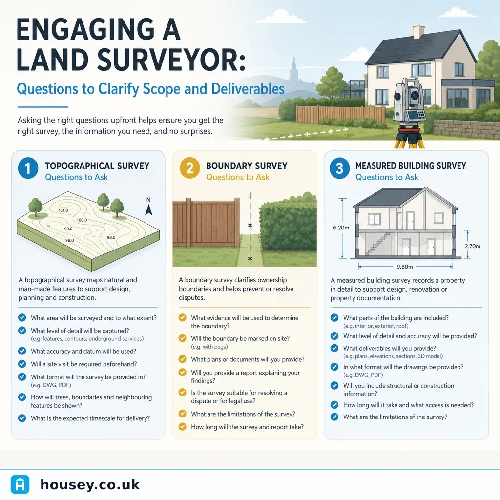
When requesting quotes from land surveyors, ask for the following in writing before accepting:
- What is the deliverable — file format (DWG, PDF, hard copy), scale, layer naming convention, accuracy standard?
- What research is included — how many years of historic title and OS archive coverage?
- What assumptions is the quote based on — site access, boundary length, plot area — and what could change the price?
- What is your RICS membership number, and can you confirm your professional indemnity insurance level?
- Will you personally carry out the fieldwork, or will it be delegated to an assistant?
- What is the programme — when will fieldwork take place and when will the report or drawing be delivered?
- Is VAT included in the quoted fee?
- If the boundary or site is more complex than anticipated, how will any additional cost be communicated and agreed before it is incurred?
Important limitations
This article provides general cost guidance and an overview of land survey types in England and Wales. Survey costs and regulatory frameworks in Scotland and Northern Ireland differ — Scottish land law operates under the Registers of Scotland and a separate legal system, and a Scottish solicitor or RICS-registered surveyor should be consulted for Scottish properties.
Nothing in this article constitutes legal advice about boundary ownership or property rights. If you are involved in a boundary dispute or considering legal proceedings, instruct a solicitor before commissioning a surveyor — the appointment and instruction of the surveyor may need to follow specific legal procedures for the evidence to be properly admissible.
All cost ranges given here are indicative and may not reflect current market conditions in your area. Always obtain project-specific quotes from RICS-registered professionals.
What to ask a qualified professional
Before instructing a land or boundary surveyor:
- Are you a full RICS member with specific experience in boundary or topographical surveys for residential properties?
- Have you previously dealt with disputes involving this type of boundary feature — hedge, wall, fence line, or ditch?
- If this matter proceeds towards a legal dispute, can your report be prepared and used as expert witness evidence?
- Do you have experience with HM Land Registry determined boundary applications under section 60 of the Land Registration Act 2002?
- Can you advise on whether a jointly appointed expert surveyor is likely to be required, and what that process involves?
- What is your professional indemnity insurance limit, and does it cover the value of the property in question?
When to get professional help
Always instruct a chartered land surveyor for boundary and topographical survey work — this is not a task that can be reliably carried out without specialist equipment and professional indemnity cover. Seek professional advice urgently if:
- A neighbour has erected a fence, wall, or structure that you believe encroaches on your land.
- You have received a solicitor's letter or legal proceedings have been threatened.
- You are under exchange deadline pressure during a property purchase and the title plan does not match the physical features on site.
- Your planning application is being held up because the local planning authority requires an accurate topographical survey and none has been commissioned.
How Housey can help
Housey connects you with qualified professionals offering topographical surveys, boundary surveying, and measured building surveys for residential and small commercial properties across the UK. Submit a brief description of your site and requirements to receive quotes from RICS-registered surveyors in your area.
Frequently asked questions
Do I need a solicitor as well as a surveyor for a boundary dispute?
In most cases, yes. A land surveyor can establish the factual position of a boundary based on physical evidence and historical records, but a solicitor is needed to advise on the legal ownership question — which depends on the deeds, conveyancing history, and potentially the law of adverse possession. For disputes heading to the First-tier Tribunal (Property Chamber), both professionals are usually required.
Can I use Google Maps or Land Registry data to determine my exact boundary?
No — both are useful for orientation but lack the accuracy needed to determine a legal boundary. Land Registry title plans are indicative only, drawn at scales of 1:1,250 or 1:2,500. A professionally produced boundary survey using total station or GNSS equipment provides the millimetre-level accuracy required for legal or planning purposes.
How long does a topographical survey take?
A topographical survey of a typical residential garden or small development site up to around 0.1 hectares usually requires half a day to a full day of fieldwork, with drawings delivered within three to seven working days. Larger or more complex sites take proportionally longer, and the surveyor should confirm the programme and output format at the quoting stage.
What is the difference between a land surveyor and a building surveyor?
A land surveyor measures the land itself — its shape, levels, extent, and boundaries — producing plans for planning, construction, or legal use. A building surveyor assesses the condition of existing structures, advises on defects and maintenance, and carries out RICS Home Surveys. Some chartered surveyors hold qualifications in both disciplines, but it is worth confirming the relevant specialism before instructing.
Sources and further reading
- Land Registration Practice Guide 40: Boundary Disputes — HM Land Registry
- Land Registration Practice Guide 76: The Determined Boundary — HM Land Registry
- Land Registration Act 2002 — legislation.gov.uk
- RICS Find a Surveyor — RICS
- Party Wall etc. Act 1996 explanatory booklet — GOV.UK
Useful next reads
 Surveys & Inspections
Understanding Property Boundaries and Party Wall Agreements
Property boundaries define the legal extent of your land; the Party Wall etc.
 Surveys & Inspections
Engaging a Land Surveyor: Questions to Clarify Scope and Deliverables
When engaging a land surveyor, clarify exactly which type of survey you need — topographical, boundary, or measured building — before agreeing a fee.
 Surveys & Inspections
Professional Property Boundary Surveying and Land Measurement
A property boundary survey precisely establishes the legal extent of your land using title deeds, Ordnance Survey data, and physical evidence.
 Surveys & Inspections
Land and Property Surveying Costs
Land survey costs in the UK typically range from around £400 for a simple boundary check to £3,000 or more for a detailed topographical or measured building survey of a large site.
 Surveys & Inspections
Surveying Large Estates and Acreage: What Property Owners Should Know
Large estates and acreage typically require a combination of surveys: a topographical survey to map contours and features, a boundary survey to confirm legal extents, and often an ecological or environmental assessment.